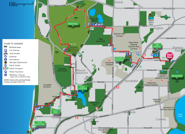
Trail Information
 The Bush to Beach Trail lies on Whadjuk Noongar land. This trail forms the east/west section of the Whadjuk Trails, currently under development by WESROC to foster a community appreciation of the remnant bushland areas in Perth's western suburbs. The trail is suitable for all walkers, with a moderate level of fitness required through Bold Park. Path surfaces vary, with the greater part of bushland areas unsealed.
The majority of the Bush to Beach trail is dog and cycle friendly, and can be walked in sections to suit walkers' abilities and available time. Through Bold Park, bicycles are prohibited on this section of the trail; however the alternate route along Underwood Avenue and connecting with Rochdale Road can be used.
The Bush to Beach Trail can be enjoyed throughout the year. As the weather in Perth in the summer can become very hot, it is always advisable to bring plenty of drinking water, and to wear sunscreen and a hat. Mobile phone coverage is good, and use of maps is available with most providers.
Near Mount Claremont, there is a section inaccessible by wheelchair. Please continue east on Fortview Road, south onto Rochdale Road and west onto Haldane Street to resume the route at the Mayfair Street intersection.